Book your 2025 & 2026 adventures Risk free.
Discover Donegal Guided Holiday


Geographically speaking, Donegal is a county of contradictions: it contains the northernmost point in the whole of Ireland — Malin Head on the remote Inishowen Peninsula and yet it is in ‘the South’ (Republic of Ireland). It is in Ulster (i.e. the nine-county province), but not in Northern Ireland. The county is very sparsely populated, with large tracts of land being uninhabited and a good deal of the open land and grazing country covered by blanket bogs.
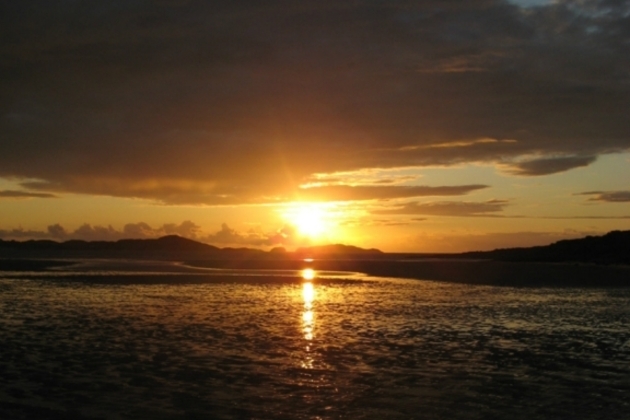
The north-western tip of Donegal, around Bloody Foreland, is known for the interplay of light and water. The rocks are given a magical pink or reddish hue when sunlight falls on them, particularly at sunset, and this is particularly noticeable on the cone of Errigal, Donegal’s highest peak. Donegal Irish is spoken in the districts of the Rosses and Gweedore, this being one of the strongest Gaeltacht areas in the country.
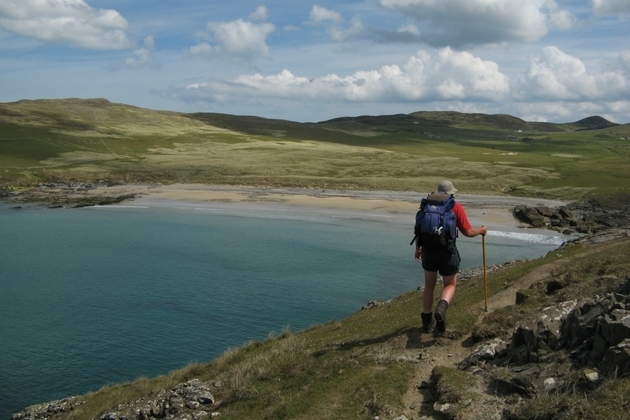
The Gaeltacht village of Glencolumbcille gets its name from St. Columbcille (Latin: Columba) who retreated there in the 5th Century. It has one of the best-preserved groupings of Early Christian pillar stones, spread over the valley. These are located at the 13 stations of the ‘turas’ or pilgrimage, still held every year on June 9th, the feast day of St. Columbcille. Donegal has some of the finest cliff scenery in Ireland, the most famous being the cliffs of Slieve League, a mountain of 595m which drops almost sheer into the sea. These cliffs stretch for 3 miles and can be best viewed from Bunglass near Teelin. A spectacular walk from here leads to the summit of Slieve League, passing over the cliff-tops and crossing the notorious arete called ‘One Man’s Pass’. The cliffs of Horn Head near Dunfanaghy also repay a visit. From here you will glimpse Tory Island, mythical home of the Fomorians, lying 12 kms. North of Bloody Foreland.
Situated just 5kms. off the coast of Donegal, Arranmore or Aran Island has been inhabited since prehistoric times and it's likely to have been one of Donegal's first coastal population centre’s. Archaeological sites on the island have been dated to the Early Iron Age (800 BC) and the island was also home to a number of Gaelic chieftains, Manus Óg O'Domhnaill (Manus O'Donnell), a cousin of the Donegal chieftain Aodh Dubh O'Domhnaill, being its most famous. Many of the Gaelic traditions practised by these families are still alive on Arranmore today and can be heard and seen on your visit.
Trip Outline
The heritage town of Ardara, a centre for the tweed industry, is your base for the first three nights as you explore the beauty of South-West Donegal. You visit Glencolumbcille with its pilgrimage sites and climb the spectacular Slieve League. You then move North to the district of Gweedore for the next three nights. On your ‘free day’ you will have time to partake in other activities if you wish and we may arrange a boat trip Aran Island, weather and time permitting. You then climb Errigal, Donegal’s highest mountain. Your final walk takes you to the cliffs around Horn Head near Dunfanaghy. The last night’s accommodation is at Letterkenny, from where there are good connections for departures via Derry, Donegal, Dublin and other centres.
Day 1 Courtesy Collection from Sligo Bus & Rail Station at 17.00 hrs. and Donegal Bus Station in the Diamond at 18.00 hrs. Arrive for overnight at our first guesthouse at Ardara. Evening meal together and a general chat about the coming week’s walks.
Day 2 Our first day we follow the old pilgrimage route at Glencolumbcille, a holy site since the days of St. Columbcille in the 6th century. We enjoy some wonderful coastal scenery along the way and visit some of the places of historical and archaeological interest that abound in this region. At the end of the walk we return to Ardara for dinner and overnight.
Walk Details — Distance: 12kms. Duration: 4½ hours. Max. Height: 300m. Grass tracks and open mountain with rocky sections and no tracks. Some road walking. Boots essential.
Day 3 Today we walk along the famous Slieve League to complete a most impressive walk across these high and spectacular cliffs on the edge of the Atlantic Ocean. The views are fantastic over Donegal Bay to Benbulben and the mountains of North Mayo. Return to our accommodation in Ardara for dinner and overnight.
Walk Details — Distance: 13kms. Duration: 5 hours. Max. Height: 750m. Grass tracks and open mountain with rocky sections and no tracks. Some road walking. Boots essential.
Day 4 Morning transfer from Ardara to Maghery near Dungloe (¾ hour). Today’s walk takes us to Croaghegly and the low hills inland from Crohy Head. We gain views of Aranmore and other islands, as well as the headlands of the Rosses dotted with lakes. Transfer to Gweedore for dinner and overnight.
Walk Details — Distance: 15kms. Duration: 4 hours. Max. Height: 245m. Grass tracks and open mountain with rocky sections and no tracks. Some road walking. Boots essential.
Day 5 This is your ‘free day’ to allow you to partake in other activities if you wish – such as cycling, horseriding, canoeing or just laze about with a book! Weather and time permitting, we may arrange a boat trip to Aranmore/Aran Island, an island of ferocious beauty located 5kms. off the Donegal Coast. Return to Bunbeg/Gweedore for dinner and overnight. There is no guided walk today. You are free to decide your own programme once you arrive on the island.
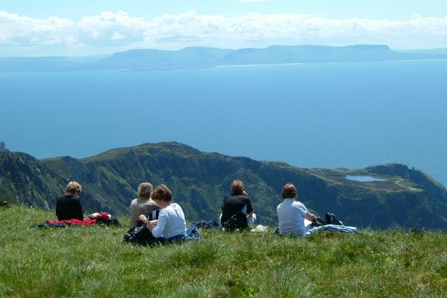
Day 6 Today, from the village of Dunlewy we climb Errigal, Donegal’s highest and best known peak. If the day is fine, we will have views southwards towards Slieve Snaght and the brooding depths of the Poisoned Glen; while to the North we will look out over a watery plain towards Bloody Foreland and Tory Island beyond. On our descent we visit the lower peaks of Mackoght (Wee Errigal) and Beaghy. Return to Gweedore for dinner and overnight.
Walk Details — Distance: 8kms. Duration: 5 hours. Max. Height: 751m. Stony tracks and open mountain with rocky sections and no tracks. Some road walking. Boots essential.
Day 7 Our last day’s walk is on the promontory of Horn Head near Dunfanaghy. This spectacular headland offers some fine cliff scenery and views across the wild waters of Sheep Haven to the Rosguill and Fanad Peninsulas. Transfer to Letterkenny for overnight and farewell evening dinner.
Walk Details — Distance: 15kms. Duration: 4½ hours. Max. Height: 250m. Grassy tracks and open moorland with rocky sections and no tracks. Some road walking. Boots essential.
Day 8 Departures. After breakfast we transfer you to Letterkenny Bus Station for your onward journey. From Letterkenny there is an excellent bus service to Derry, Donegal, Dublin and to all major towns and airports in Ireland.
Recommended reading: ‘No News at Throat Lake’ by Laurence Donegan. ‘Donegal Highlands’ by Liam Ronayne and Pat Cowley. ‘Hillwalker’s Donegal’ by David Herman.


